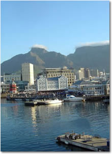
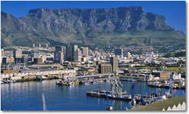
Cape Town is the third most populous city in South Africa, forming part of the metropolitan municipality of the City of Cape Town. Cape Town is the provincial capital of Western Cape Province as well as the legislative capital of South Africa, where the national Parliament and many government offices are located. Cape
Town is famous for its harbour as well as its natural setting, including such well-known landmarks as Table Mountain and Cape Point. Often regarded as one of the world's most beautiful cities because of its geography, Cape Town is the most popular South African destination for international tourists.
Cape Town originally developed around its harbour, as a refueling station for Dutch ships sailing to Eastern Africa, India, and Asia. Founded in 1652, it was the first permanent European settlement in sub-Saharan Africa. It quickly outgrew the first European outpost at the Castle of Good Hope, and remained the largest city in South Africa until outpaced by the new city of Johannesburg following the discovery of gold and diamonds in the Transvaal in 1887.
Cape Town is also served by Cape Town International Airport, the second-busiest airport in South Africa, and a major gateway to the city for tourists.
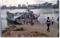
Dar Es Salaam [means "House of Peace"] (Dār as-Salām), formerly Mzizima, is the largest city (population 2,500,000 estimated 2003), economic centre and former capital of Tanzania. The city serves as the capital for the surrounding Dar es Salaam Region as well as, arguably, the de facto current capital of Tanzania. Though inland Dodoma is the official capital, the vast majority of federal government employees live in Dar and most major political figures maintain residences here.
Located on a harbour on the Indian Ocean, its main railways originate in or near the city. Local industries include trade, food products, textiles, cement, and pharmaceuticals. About one half of Tanzania's manufacturing employment is located here despite the fact that Dar holds only ten percent of the population.
Though the city has a low violent crime rate, this is increasing along with the already high number of instances of theft as inequality increases and the amount of money available from Tanzania's thriving aid industry increases. One common nickname of the city is "Bongo" (meaning "brain" in Swahili), essentially implying that street smarts are what is needed to survive here.
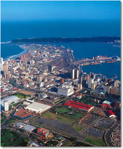
Durban is a city in KwaZulu-Natal Province, South Africa. It is also known by the Zulu word eThekwini, (which means "at the harbour", from the Zulu word itheku). Since 2000, a number of towns, including Durban, have been part of the eThekwini Metropolitan Municipality.
Durban is being marketed as "South Africa's Playground". It has a population of about 3.1 million people with diverse cultures including a large Indian community making Durban the second largest city in South Africa.
While Johannesburg has embraced its new Afro-centric nature, and Cape Town has held on to its Euro-centric culture, Durban has emerged as an Ethno-centric city—a polyglot of Eastern, Western and African cultures, each of which give Durban a distinctly unique flavour.
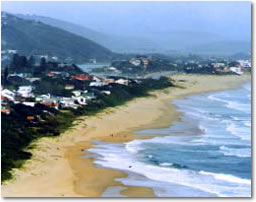
Durban is primarily a "holiday city"/beach resort, but at the same time is Africa's busiest container port and has a substantial industrial sector. The port is one of the world's largest natural deep water ports.
The long continuous stretch of hotels that line the city's beachfront is known as Durban's Golden Mile.
The Etosha pan is a large endorheic salt pan in the north of Namibia. It was first explored by the Europeans John Andersson and Francis Galton in 1851. American commercial traveller McKeirnan visited the area in 1876.
The area exhibits a characteristic white and greenish surface, which spreads over hundreds of kilometers. The pan developed through tectonic plate activity over 10 million years. In prehistoric times water collected itself there and formed a lake.
It is assumed that today's Kunene River fed the lake at that time but over time plate movements caused a change in river direction causing the lake to run dry and leave a salt pan.
The year-round meager vegetation lends gives the Etosha its characteristic green colouring. In particularly rainy years the Etoscha pan becomes a lake approximately 10cm in depth and becomes a breeding ground for Flamingos, which arrive in their thousands.
The Etosha area was used as a backdrop during the filming of 2001: A Space Odyssey.
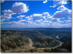
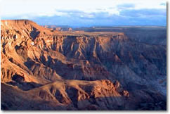
The Fish River Canyon is located in Namibia. It is the second largest canyon in the world (but not the second deepest), as well as the second most visited tourist attraction in Namibia. It features a gigantic ravine, in total about 100 mi (160 km) long, up to 27 km wide and in places almost 550 metres deep. It has been gouged out of the surface of the land in the course of 650 million years by the forces of water, wind, gravity and earth movements.
The Fish River is the longest interior river in Namibia, but its flow in the present is a puny trickle compared with the immense volume of water that poured down its length in ages past. It cuts deep into the plateau which is today dry, stony and sparsely covered with hardy drought resistant plants such as succulents.The river flows intermittently, usually coming down in flood in late summer, and when it ceases to flow.
Fish River Canyon
becomes a chain of long narrow pools on the sandy rock-strewn floor of the chasm. At the lower end of the Fish River Canyon, the hot springs resort of Ai-Ais provides an oasis in the desolate rocky wastes.
The official view points can be found around Hobas, a camp site, 70 km north of Ai-Ais. This part of the canyon is government owned.
But there is an aspect of this wonderful land, which makes it quite different to the Grand Canyon in the USA: the fact that about 90 km of this canyon is privately owned and incorporated into Private Nature Parks. Therefore, other places of interest and equally spectacular viewpoints, are found on private land on both sides of the Fish River Canyon.
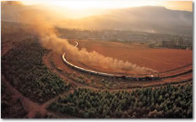
George is the administrative capital of the South Western Cape, was formerly known as George Town, named after the reigning English monarch, King George III. This bustling town at the foot of the majestic Outeniqua Mountain was declared a drostdy by the Earl of Caledon on 23 April 1811. George gained municipal status in 1837.
The town is very centrally situated: halfway between Cape Town and Port Elizabeth and centre of the Garden Route. It is situated on a 10 kilometre plateau between the majestic Outeniqua Mountain to the north and the Indian Ocean to the South.
The Garden Route has a Mediterranean Maritime climate, with moderately hot summers, and mild to chilly winters. It is one of the richest rainfall areas, most of which occurs in the winter months, brought by the humid sea-winds from the Indian Ocean. Any time of the year is good for visiting the area, depending on whether one enjoys a peaceful retreat during the winter months, or a bustling holiday destination during the summer.
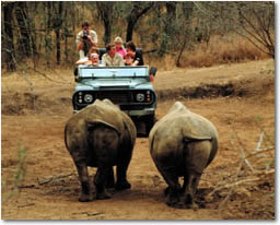
Hluhluwe-Umfolozi Game Reserve, located 280 km north of Durban, is the oldest proclaimed park in Africa. It consists of 960 km² of hilly topography in central Zululand, KwaZulu-Natal, South Africa.
- Throughout the park there are many signs of Stone Age settlements.
- This area between the Black and White Umfolozi rivers was also once the personal hunting area of King Shaka Zulu.
- The Hluhluwe and Umfolozi Game Reserves were proclaimed separately in 1895. Their turbulent histories have included temporary deproclamations for veterinary programs and mass slaughter of game under the banner of "disease control"!
- Operation Rhino was started during the 1960s, resulting in the white rhino being saved from extinction. Hluhluwe-Umfolozi is now focusing its efforts on saving the endangered black rhino, whose number in Africa has dwindled from 14 000 to a pitiful 2 550 in the past decade. You'll find at least a fifth of the world's black and white rhino population here.
- It was also here that the first guided wilderness trails in Southern Africa were run.
- Both reserves were joined in 1989 through the Corridor Reserve.
- Due to inbreeding Hluhluwe-Umfolozi introduced the Lion Project in 1999. This project is to save the lions by infusing new blood into the existing bloodlines.
Hoedspruit (hat creek) is a town situated at the foot of the in the Limpopo Province of South Africa on the old Selati railway line from Phalaborwa to Kaapmuiden.
The Town has grown in recent years due to its close proximity to the Private Game reserves to the West of the Kruger National Park. The Town used to have a Large Air force Base, but this has now been converted to a shared Military/Private airport and re-named "Eastgate Airport". There are now several scheduled airlines flying to this destination.
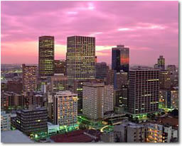
This ‘Place of Gold’ as the Sotho word for Gauteng suggests, harbours the gold fields of South Africa. These are just part of one of the largest industrial regions in the Southern Hemisphere.
No-one could have imagined the repercussions when an unemployed miner found a stone bearing traces of gold in 1886. This seemingly insignificant event led to the discovery of the world's richest natural treasure trove.
People flocked to the area from all ends of the earth and the open pastoral landscape changed almost overnight. Shantytowns sprang up and were rapidly transformed into modern concrete cities. Johannesburg became ‘The Gold Capital of the World’, and the entire country was catapulted into an economic boom. Industrial development was confined to certain areas so that city dwellers may still find rural places and leisure resorts to retreat to. Unfortunately, violent crime is a major problem in the Johannesburg area and visitors should listen carefully to advice on where to go.
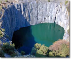
In 1866, Erasmus Jacobs found a small white pebble on the banks of the Orange River, on the farm De Kalk, near Hopetown. The pebble turned out to be a 21.25 carat (4.25 g) diamond. In 1871, an even larger 83.50 carat (16.7 g) diamond was found on the slopes of Colesberg Kopje, and led to the first diamond rush into the area.
As miners arrived in their thousands, the hill disappeared, and became known as the Big Hole. A town, New Rush, was formed in the area, and was renamed to Kimberley on 5 June 1873, after the British Secretary of State for the Colonies at the time, John Wodehouse, 1st Earl of Kimberley.
The British, who had control of much of South Africa, were prompt to annex the area of the diamond mine. The Boers were upset by this, because they wanted it to be a part of the Orange Free State.
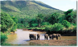
Kruger National Park is the largest game reserve in South Africa. It is roughly the same size and shape as Israel or Wales. It covers about 20,000 square kilometres and extends 350 km from north to south and 60 km from east to west.
To the west and south of the Kruger National Park are the two South African provinces of Mpumalanga and Limpopo. In the north is Zimbabwe, and to the east is Moçambique. It is now part of the Great Limpopo Transfrontier Park, a peace park that links Kruger National Park with the Gonarezhou National Park in Zimbabwe, and with the Limpopo National Park in Mozambique.
The park is part of the Kruger to Canyons Biosphere, an area designated by the United Nations Education and Scientific Organisation (UNESCO) as an International Man and Biosphere Reserve (the "Biosphere").
Ladysmith is a town on the banks of the Klip River, (stone river), in the uThukela District of KwaZulu-Natal, South Africa. It is 230 km north-west of Durban and 365 km south of Johannesburg. Important industries in the area include food processing, textiles, and tires.
In 1847 a number of Voortrekkers settled in the area and the town was founded in 1850 by Boers as the capital of the Republic of Klip River with Andries Spies as their commandant. The republic was annexed by the British in the same year. It was named after the Spanish wife of Sir Harry Smith, Lady Juana Maria Smith. Sir Harry Smith was the British general governor of Cape Colony and high commissioner in South Africa from 1847 to 1852. A fort was built in 1879 to protect the villagers from the Zulus.
Lüderitz, Namibia is a harbour town on one of the least hospitable coasts in Africa. It was founded in 1883 when Heinrich Vogelsang purchased Angra Pequeña and some of the surrounding land on behalf of Adolf Lüderitz, a hanseat from Bremen, Germany, from the local Nama chief. Lüderitz began its life as a trading post, with other activities in fishing and guano-harvesting.
In 1909, after the discovery of diamonds nearby, Lüderitz enjoyed a sudden surge of prosperity. Today, however, diamonds are mostly found elsewhere and offshore, and Lüderitz has lost a lot of this interest.
The harbour has a very shallow rock bottom, making it unusable for modern ships; this led to Walvis Bay becoming the centre of the Namibian shipping industry. Recently, however, the addition of a new quay has allowed larger fishing vessels to dock at Lüderitz.
Malelane is a small town in Mpumalanga, South Africa. The farms in the region produce sugarcane, subtropical fruit and winter vegetables. The town was proclaimed in 1949 and the name was corrupted from the swazi expression "eMlalani" which means place of the palms.
The town of Matjiesfontein is a national monument. James Douglas Logan developed the Victorian buildings that make up the town as a health resort. Matjiesfontein was the first village to have electricity and water-borne sewage.
Many high-ranking people, such as Cecil John Rhodes and Sir Randolph Churchill (father of Sir Winston Churchill), were seen at the resort. During the Anglo-Boer War, the British used Matjiesfontein, as a base. At the same time, Logan built the Milner Hotel, with its turret that was used as a lookout by the troops.
Mkhaya Private Game Reserve is the Kingdom’s refuge for endangered species. It is self supporting through the breeding of indigenous pure bred Nguni cattle, which were close to extinction. It has also had success with black and white rhino, roan, sable, eland and tsessebe. It lacks the commercialism of other game reserves and its luxury tented camp is a model for sensitive development.
Managed entirely by friendly Swazi staff, the daily camp routine revolves around delicious meals cooked on the fire, Land Rover game drives and guided walks. Mkhaya is the Kingdom’s VIP safari destination.
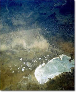
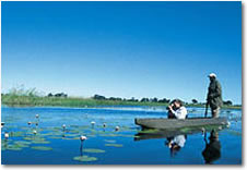
The Okavango Delta (or Okavango Swamp), in Botswana, is the world's largest inland delta.
"Where all this water goes is a mystery", Aurel Schultz, 1897
The area was once part of Lake Makgadikgadi, an ancient lake that dried up some 10,000 years ago. Today, the Okavango River has no outlet to the sea. Instead, it empties onto the sands of the Kalahari Desert, irrigating 15,000 km² of the desert. Each year some 11 cubic kilometres of water reach the delta. Some of this water reaches further south to create Lake Ngami.
The water entering the delta is unusually pure, due to the lack of industrialization along the Okavango River. Because the water does not have an outlet to the sea, significant quantities of salt have been precipitated beneath the islands as the water passes through the sand aquifer.
The waters of the Okavango Delta are subject to seasonal flooding, which begins about mid-summer in the north and six months later in the south. The water from the delta is evaporated relatively rapidly by the high temperatures, resulting in a cycle of cresting and dropping water in the south. Islands can disappear completely during the peak flood, then reappear at the end of the season
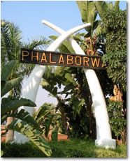
Phalaborwa is a town situated at half way up along the length of the Kruger National Park in Limpopo Province of South Africa. Large scale mining of phospates, copper and other minerals takes place here.
The town is known for being very hot, with daily temperatures often going above 35 °C in summer. It is often referred to as the land of two summers because its average winter temperature is about the same as the average summer temperature of the rest of South Africa.
The name "Ba-Phalaborwa", given to the area by the Sotho tribes who moved here from the south, means better than the south. The Sotho mined and smelted copper and iron ore here as far back as 400AD.
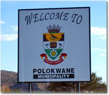
Polokwane, previously known as Pietersburg is the capital of Limpopo Province, South Africa. The population is about 130 000, and is the metropol of the Limpopo area.
In the 1840s, Voortrekkers under the leadership of Andries Potgieter established Zoutpansbergdorp, a town 100 kilometres south-east. This settlement had to be abandoned because of clashes with the local tribes.
They founded a new town in 1886 and named it Pietersburg in honour of Voortrekker leader Petrus Jacobus Joubert. The town became a city on 23 April 1992 and on the 11 June 2003 changed its name to Polokwane. A small game reserve is located in the outskirts.
Port Elizabeth is a city in South Africa, situated in the Eastern Cape Province, at 33°58′S 25°36′E. The city is located on Algoa Bay, and is one of the major seaports in South Africa.
Port Elizabeth is just south of the expanding Addo Elephant National Park, and boasts the highly successful University of Port Elizabeth which has merged with PE Technicon and Vista University in 2005 to form the Nelson Mandela Metropolitan University.
Since 1998, Port Elizabeth has been in a friendship partnership with the Swedish City of Gothenburg. A partnership fostering development of common fields of interest such as solid waste management, public libraries, sport and tourism.
In 2000 Port Elizabeth became the sixth sister city to Jacksonville, Florida.
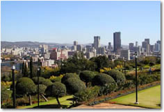
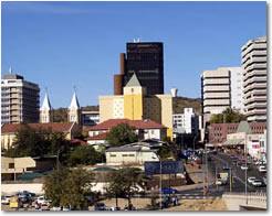
Pretoria (now called Tshwane) is the Administrative Capital of South Africa, with grand buildings with most of the foreign embassies located here, thus giving the whole city a dignified presence.
Although it is quite close to Johannesburg, it has a totally different feel. Avenues of purple flowering jacaranda trees are wide enough to turn a team of oxen pulling a cart belonging to the large numbers of Voortrekkers who arrived here in the 1850s.
Sculptures and monuments attest to the Afrikaner history and great care has been taken to preserve the fine architecture in the city center such as Church Square. Overlooking the whole of the city from a hilltop are the magnificent Sir Herbert Baker designed Union Buildings, built in golden stone with Italian tiled roofs, a Romanesque amphitheatre and African sculptures.
Progress has brought high-tech shopping centres, museums, art galleries and multi-culinary restaurants. The city has four universities, a number of scientific institutes and an abundance of open spaces with parks, bird sanctuaries, nature reserves and a zoo.
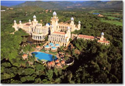
Sun City is a luxury South African casino resort, situated in the North West Province. It is located about two hours' drive from Johannesburg, close to the city of Rustenburg. The complex borders the Pilanesberg National Park.
Sun City was developed by the hotel magnate Sol Kerzner as part of his Sun International group of properties. It was officially opened on 7 December 1979; at the time it was located in the bantustan of Bophuthatswana.
As Bophuthatswana was classified as an independent state by South Africa's apartheid regime (although unrecognized as such by any other country), it was allowed to provide "immoral" (in the eyes of the South African government) entertainment such as gambling and topless revue shows, which were banned in South Africa. These factors, as well as its relatively close location to the large metropolitan areas of Pretoria and Johannesburg, ensured that Sun City soon became (and stayed) a popular holiday and weekend destination.
Swakopmund is a city in Namibia, with around 35,000 inhabitants. It is Namibia's premier beach resort. It is one of the best preserved examples of German art-deco architecture in the world. It was founded in 1892 as the main harbour for German South-West Africa.
The majority of towns and villages in Namibia have grown out of indigenous settlements and very often were located close to sources of water. Names of places given by original inhabitants were very descriptive and in many cases those names were retained by European settlers who sometimes simplified pronunciations of the names. The Nama word "Tsoakhaub" can be translated as "excrement opening" which was an offensive but accurate description of the waters of the Swakop River when it flooded, carrying masses of mud, sand, pieces of vegetation and animal corpses to the Atlantic Ocean.
The Nama name was changed to "Swachaub" by German settlers, and with the proclamation of Swakopmund as an independent district of German South-West Africa in 1896, the present way of writing Swakopmund came into use.
The small Kingdom of Swaziland borders South Africa and Mozambique. It is alive with culture, yet totally relaxed in an endearingly lazy way. It has all the makings of idyllic rural Africa, with friendly people, simple picturesque thatched villages, colourful crafts and everything or nothing to do. The vast tree plantations contrasts starkly with small-time farming providing many with a subsistence living.
The Royal Ezulwini Valley is where most monuments, museums, crafts and culture is to be found and many of the hotels and guest houses. It is here that King Mswati III lives with his many wives and where he chooses another at the annual Reed Dance.
Swaziland is also renowned for its casinos frequented in the past by many South Africans, who now have their own entertainment resorts. This country is an absolute delight to visit and you can go on safari in one of several wildlife reserves or take advantage of the fabulous scenic hills and valleys through many adventure sports and activities.
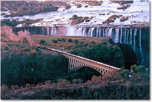
The Victoria Falls are one of the world's most spectacular waterfalls. The falls are situated on the Zambezi River, on the border between Zambia and Zimbabwe, and are roughly 1.7 km (1 mile) wide and 128 m (420 ft) high. They are considered a remarkable spectacle because of the peculiar narrow slot-like chasm into which the water falls, so one can view the falls face-on.
David Livingstone, the Scottish explorer, visited the falls in 1855 and named them after Queen Victoria, though they were known locally as Mosi-oa-Tunya, the "smoke that thunders". The falls are part of two national parks, Mosi-oa-Tunya National Park in Zambia and Victoria Falls National Park in Zimbabwe, and are one of Southern Africa's major tourist attractions. They are also a UNESCO World Heritage Site.
Windhoek area is at a refreshing altitude amongst rolling bush-dotted hills and is well watered by rain. It does however, get so hot that the rain evaporates soon after each dramatic downpour. Winters are bright but very chilly at night and summers wonderfully hot.
As capital cities go, Windhoek is very relaxed with a whole mixture of Namibia's tribes strolling the streets. Many are in traditional costume and others are in stylish contemporary clothes often with magnificent plaited hairstyles. Many people head out to Daan Viljoen Game Reserve for weekends of watersports and relaxation. Most visitors to Namibia fly into Windhoek and it is a great place to purchase arts and crafts before jetting off home.
Witbank is situated on the highveld of Mpumalanga, South Africa. The name Witbank is Afrikaans for White Ridge and is named after a white sandstone outcrop where wagon transport drivers rested. Witbank is in the coal mining area with 22 collieries in an area no more than 40 km in any direction. There are a number of coal power stations nearby, as well as a steel mill requiring coal, Highveld Steel and Vanadium Corporation.
Witbank was established in 1890 and early attempts to exploit the coal deposits failed until the railway from Pretoria reached the area in 1894. It was proclaimed a town in 1903 and became a municipality in 1914.
Worcester, South Africa is a town situated about 120 km from Cape Town, in the Breede River Valley.
It was formed in 1820 after the joining of two farms, Roodewal and Langerug, and named after the Marquis of Worcester, Lord Charles Somerset's brother.