** PLEASE DESCRIBE THIS IMAGE **
Home
** PLEASE DESCRIBE THIS IMAGE **
Africa
** PLEASE DESCRIBE THIS IMAGE **
Canada
** PLEASE DESCRIBE THIS IMAGE **
Europe
** PLEASE DESCRIBE THIS IMAGE **
Mexico
** PLEASE DESCRIBE THIS IMAGE **
United States
** PLEASE DESCRIBE THIS IMAGE **
Contact US
dd
Email Newsletter
 
** PLEASE DESCRIBE THIS IMAGE **
Copper Canyon Rail Journeys: View from the Posada Mirador in Divisadero
Information & Reservations


Copper Canyon Rail Tours & Trips

Copper Canyon Rail Journeys


Route Guide
To make use of the railroad log, you must carefully watch for the kilometer posts along the track. There is a total of 39 bridges and 87 tunnels between the cities of Chihuahua and Los Mochis and the train makes a journey of approximately 14 hours. The number appearing on each of the post is its distance from Ojinaga. Each tunnel is also numbered on a small plaque placed on the right hand side of the entrance.
Kms
Description
268
Chihuahua City.  Gateway to Copper Canyon, elevation 4660 ft. Capital of Mexico´s largest state.  Well-kept city with enough tourist attractions to fill a full day and enjoy its traditional hospitality.
303
Palomas.
322
Santa Isabel
346
Tunnel No. 1 (400 ft long)
346
Tunnel No. 2 (367 ft long)
350
San Andres.  This village was founded in 1696 by the Franciscan missionaries  named San Andres de Osagiqui.  Here is the church where Pancho Villa married Luz Corral.
360
Bridge “Viaduco Aldana” (330 ft. long).
362
Bridge “Aldana” (503 ft. long).
381
Anahuac.  This modern town was first named Charco Largo.  It is now an important industrial center with cellulose and viscose plants.
382
Bustillos Lake on the right
401
Cuauhtemoc. Named after the last Aztec emperor; rich apple producing area.
401.1
Mennonite Country. The Mennonites originally settled in this area in 1921-22
420
First Continental Divide.
426
Pedernales.
452
Estacion Lopez Mateos (La Junta)
477
Bridge “Rio San Pedro” (295 ft long).
484
Terrero.
503
Pichachic. Founded by Jesuit Missionaries
513
Ataros
523
Treviño. Second Continental Divide
531
San Juanito.  It is 8,000 feet above sea level and was established with the arrival of the railroad in 1906.  It is the coldest town in Mexico.
555.8
Tunnel No. 3 (982 ft long)
563
Tunnel No. 4  It is 4,134.8 feet long, the second longest in the line. As the train goes through the tunnel it also crosses the continental divide for the third time.
564
Creel. Elevation 7,735 feet. It is the heart of the Tarahumara homeland and gateway fo the Sierra Tarahumara.  Its principal industries are lumber and the railroad.
583
Los Ojitos (highest point, elevation 8,071 ft)
585
El Lazo. Beginning a sharp descent this area is called “The Loop” because at this point the railroad makes a complete circle and crosses over itself.
622
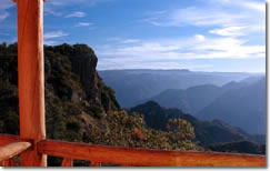
Divisadero. This a natural lookout point.  Overlooks a tributary of the Rio Urique in the Barranca del Cobre 4,135 feet down. It has a hotel on  the rim of the canyon.
626
Posada Barrancas Station
637
San Rafael
638.5
Túnel No. 17 La Laja. 1,512 ft long
639
La Laja bridge.  695.4 feet. A good picture from the left side of the train after you cross the bridge.
662
Cuiteco.  A little village originally pure Indian, until the Jesuit missionary Father Salvatierra, established a mission here in 1684.  The area is known to produce the sweetest apples in Chihuahua.
669
Bahuichivo,  Lumber town,  this is the station where tourist going to Cerocahui should get off (10.5 miles).  Cerocahui was established as a mission in 1681 by Father Salvatierra.  From that location a traveler can see the most spectacular views of Urique Canyon.
693
Tunnel 38.  Jesus Christ face.
703.2
Tunnel No. 48 (623.3 ft long).  Beautiful vistas on the left, after going through the tunnel
704
Placa Conmemorativa. This marker made of rail shows the spot of the dedication of El Chihuahua al Pacifico, on November 24, 1961.
704.7
La Pera. tunnel  No. 49, 3,074 feet long and shaped like horseshoe so when you come out the scenery that was on your left will be on the right.
708
Temoris  3,365 feet above sea level.  A mission founded by the Jesuits in 1677 named Santa Maria Magdalena de Temoris (Temoris was the name of the Indians that inhabited the region).
719
Banana Tree Waterfall: In the middle of the waterfall you will find a banana tree.
722
Julio Ornelas. Beyond this point papayas, mangos and avocados are grown
748
Chinipas bridge over the Chinipas rivers.  This is the highest bridge on the line about 335 feet above the ground and 1018.5 feet in length.
754.6
Tunnel 86.  The last and longest in the rail line, 5,966 feet long
779
Agua Caliente Bridge:  Over Rio Fuerte.  This is the longest one on the railroad, 1,637 feet long
839
El Fuerte StationA short distance from the train station is El Fuerte
921
Los Mochis. The end of the line. Los Mochis means “place of turtles” in the Mayo Indian dialect, was founded in 1903.
Chihuahua to Los Mochis
Points of Interest Along the Ferromex “Chepe” Railroad Line
Leaving Chihuahua
About one hour after you leave Chihuahua, you will go through a small range of mountains. It was in these small canyons that some of the first battles of the revolution were fought. Soon a stop will be made in the little town of San Andres. This is where Mrs. Villa was born, and it was also here that she met Pancho and married him in the little church you can see in the center of the town.
Farming
As you continue, the road opens into a valley where you will see lots of cultivated lands. It is all dry farming, and the crops raised here are mainly corn and beans.
Kilometer Post 380
At this point, to your left-hand side, a big plan can be seen. This is an Industrial Center.
Lake
The lake you see to your right is called “Laguna de Bustillos”, a partly contaminated and very shallow natural lake.
Mennonite Country
As you leave the little town of Anahuac, to your right will come in sight part of the Mennonite country. The small villages you see in the distance are where they live and are called “camps”.
Trading Center
The next town you come to is Cuauhtemoc. It was named after the last Aztec Emperor, and it is here that the Mennonites do most of their trade and shopping.
Round House
Three hours have passed since you left Chihuahua. La Junta or Lopez Mateos station should be coming in sight by now. This is where most of the railroad shops were located. Some of them could be seen to the left. At this point another line branches north to Ciudad Juarez.
Pine Country
The rain will start climbing into timber country until you come to San Juanito, one of the main lumber towns along the line.
Kilometer 563 - Continental Tunnel
To the right you can see part of the old line, the deviation of the line and the construction of this 4,134 foot tunnel, (second longest on the line) saving three kilometers in distance and achieving a 2% grade instead of 2.5% grade that existed.
Creel Station
You are now in the heart of the Tarahumara country. This is the center and the starting point for all the activities of the Tarahumara country. Beyond this point, small corn patches, where the Indians farm, will be seen on the hill sides.
Kilometer 583
This point is called “Los Ojitos” and is the highest point on the line, 8,071 feet above sea level.
Kilometer 585 - El Lazo (The Loop)
From this point the unfolding of the line may be observed to form a loop and cross a tunnel precisely under the bridge you are crossing now.
Kilometer 622 - Divisadero (Looking Point)
This is where you will have a chance to take pictures of one of the main canyons, “Urique Canyon”.
Kilometer 637 - San Rafael
This is a terminal. Some of the trains will change crews here. They will also take on water and fuel.
Kilometer 704 - Cuiteco
The orchards you see to your left are apple, growing practically wild along the creek. They are known to be the sweetest in the state.
Kilometer 704 - Temoris
From this point you can observe the extraordinary development of the line unfolding in three levels. It was here that President of Mexico, Lic. Adolfo Lopez Mateos officially declared the line open, in November 23, 1962.
Kilometer 728 - Tacuina
To your right and very close to the tracks, you will see the unusual sight of a tree growing out of a rock.
Kilometer 748 - Chinipas Bridge
This is the highest bridge of the line, 335 feet high by 955 long.
Kilometer 754 - Longest Tunnel
This is tunnel number 86, the last and longest one of the line, 5,966 feet long.
Kilometer 781 - Rio Fuerte Bridge
This is the longest bridge on the line, 1,837 feet long. It crosses the Rio Fuerte.
Kilometer 883 - San Blas Terminal
This is the connecting point with Ferromex “Chepe”. Your next stop a half hour from here will be Los Mochis.

Please contact us at:
Info@railsnw.com

Rail News & Updates
 

Come join us on one of our unforgettable trips to the Copper Canyon region of Northern Mexico. Trips can be customized to fit any budget or schedule.


With key dates this Holiday season already booking up, we recommend making your reservations soon by booking online. Or emailing us if you have any questions.


Copper Canyon Info
 
Starting in El Paso
 
Starting in Chihuahua
 
Starting in Los Mochis
 
Starting in Mazatlán
 
Customer Service